General Information

Horseshoe Canyon is a remote section of Canyonlands National Park. It is possible for the drive out and back to take longer than the actual hike. The hike itself is 6 miles round trip, with a steep ascent to get back out of the canyon. We do not know of a local campground, but it is permissible to camp in the parking lot of the canyon since that is BLM (Bureau of Land Management) land. This may be useful if you are out there and it begins to rain really hard since the dirt road to leave can become impassable when wet. It is advisable that you bring extra food and water. There is a public toilet at the parking lot, but no running water.
Nothing is close to Horseshoe Canyon. We stopped here between a trip to Arches National Park and Capital Reef National Park. Bryce Canyon and Zion are a bit further than Capital Reef.
Beginning the Hike

Horseshoe Canyon is located in Canyonlands National Park, but you don't access it by the normal entrance. Instead, we drove back up 191 from Arches National Park to 70 and headed west. When we got to Green River, we turned left on to a dirt road. That road was 47 miles of dirt and desert. During rain, it may be difficult to get a little rental car through.
After an hour or so, we glimpsed a dirt road while passing it at about 80 mph, and slowly came to a stop about a quarter mile away. This part of Utah is probably one of the few areas sparsely populated enough in which you can do this: simply put the car in reverse and back up down the highway to where you were supposed to be. The dirt road leads to the Horseshoe Canyon trail head - be careful not to hit any cows on the way (it's open range). We got a map from the Canyonlands ranger station to help us.
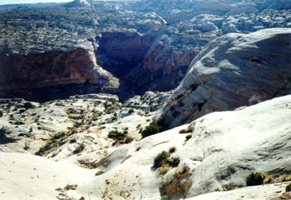
Below the parking area the canyon opens in strangely smooth pale rock. An easy descent over this interesting feature brings you to the bottom of the canyon, from which you proceed downstream (right). Along the way keep an eye out for small informational signs against the canyon walls indicating the presence of petroglyphs or pictographs. Most of these are typically small in scale but worth checking out. Remember to look up, as some of the pictographs are above your head.
Pictographs Along the Way

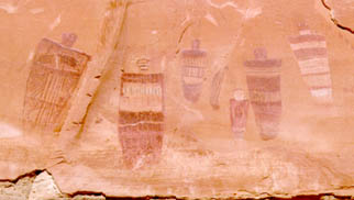
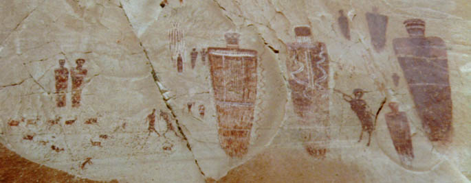
The hike along the base of the canyon was very easy, so we were able to concentrate on pictograph hunting without worrying about our footing. One of the images we found had a triangle of animals (shown above) with two men to the left that looked like they might be fighting. Large ghost-like figures are present on the right. It seems as though there are several different styles in this area, perhaps painted by different people or at different times.
The Great Gallery
The real prize is about two miles along the canyon, on the right wall. Fully life-sized and larger figures adorn the walls (picture below), along with numerous smaller figures. Looking at them as they loomed over us, they seemed to our untrained eyes to embody some supernatural or religious purpose. We were fortunate in that there were only two other people there when we arrived, and they only wanted to photograph the figures and we were able to enjoy the presence of the figures in relative silence.

Some of the figures are mere silhouettes, while others have more extensive detail. There are figures hunting, what appear to be standing figures with horns, such as a shaman might wear, and even one penguin shaped creature. There are also lines of animals as if on migration, and a variety of other symbols. The area is roped off to discourage further destruction and graffiti from visitors that destroys these artifacts. Please do not touch any of the pictographs because oils from the hand can damage the fragile images. If you see other visitors touch the pictographs, please remind them not to. They may not know that they are doing damage.
The hike out retraces the walk in. Because you had to hike into the canyon at the beginning, the hike out is strenuous for the average person. You should allow plenty of time to get out and bring a flashlight and an ample supply of water in a day pack. We got all of the hiking and driving information we needed from Canyonlands National Park (801) 259-7164 and the Hans Flat Ranger Station (801) 259-2652
The Weather
The weather in the canyon is similar to that of Moab, Utah. Since we were not able to get specific statistics on this particular area, here are Moab statistics.
Monthly Historical Averages
| Jan | Feb | Mar | Apr | May | Jun | Jul | Aug | Sep | Oct | Nov | Dec | |
|---|---|---|---|---|---|---|---|---|---|---|---|---|
| High (F) | 42 | 52 | 62 | 72 | 82 | 93 | 99 | 97 | 87 | 74 | 58 | 45 |
| Low (F) | 18 | 26 | 32 | 42 | 50 | 58 | 64 | 63 | 53 | 41 | 31 | 21 |
| Precipitation (in) | .56 | .43 | .85 | .98 | .72 | .48 | .83 | .86 | .75 | 1.16 | .74 | .65 |
Phone Numbers and Email Addresses
| Canyonlands National Park | 435 259-7164 | 2282 S. West Resource Blvd. Moab, UT 84532-3298 |
| Hans Flat Ranger Station | 801 259-2652 |
Directions
- From Moab, take 191 to 70 W for 30 miles
- 24 S for 24 miles
- Turn left on to dirt road with Horseshoe Cyn sign. The dirt road is 20-30 miles to parking lot.
